
Start from the exact item
Identify the selected layer, service URL, web map ID or data-source key. Similar titles and partial-name matches need review before tracing.
InfraSpatial Solutions / GIS automation
Before changing a feature class or retiring a service, trace the maps and applications that rely on it. Our dependency workflow connects the source data to the people-facing tools it supports.
Real application · synthetic demonstration data
See the application results01 / The requirement
A request to change an inspection layer starts in a web map. The same source may also feed another service, a public map or a third-party application. The change review needs those connections and the records that establish them.
Identify the selected layer, service URL, web map ID or data-source key. Similar titles and partial-name matches need review before tracing.
Use “Used by” to find potential consumers of a change. Use “Depends on” to investigate the resources an application requires. Keep sharing relationships separate from runtime dependencies.
Carry the relationship record, source and target keys, route and snapshot date into the change review. A connection shows potential exposure; its operational effect still needs testing.
02 / The workflow
InfraSpatial Solutions brings inventory collection, dependency evidence and operational review into one repeatable process.
Capture accessible records, permissions, scan errors and snapshot time.
Output: dated inventoryResolve identifiers and relationships; flag duplicates and missing targets.
Output: dependency indexFollow consumers from the selected source or dependencies from an application.
Output: affected-item routesCheck coverage, unresolved references, ownership and usage context.
Confirm missing records and external consumers with owners. Correct the inventory and repeat the trace.
Return to collection and checksAgree the change plan, test affected workflows and record rollback steps. An inventory result alone does not authorize a production change.
The chart describes our delivery process. The application captures below demonstrate the dependency-tracing stage.
03 / Application results
What would need review if the Hydrant inspections data source changed? We selected that source in the desktop application and ran an Impact trace through four levels.
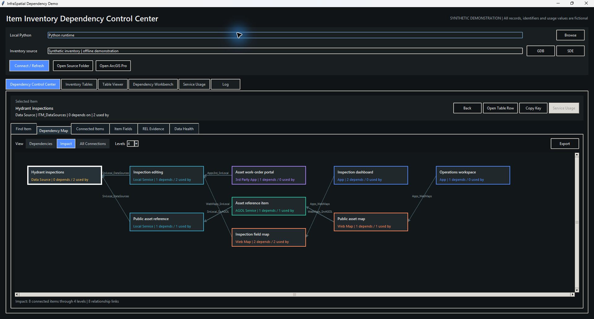
Two service branches reach web maps, a portal service item and three applications. The graph shows eight distinct relationship links; arrowheads show which item depends on another.
Select the screenshot to inspect it at full size.Actual desktop application captures using a purpose-built synthetic inventory. All names, identifiers and usage values are fictional, and the demo uses neutral table prefixes and source labels; the application's tracing logic is unchanged.
The following routes summarize the captured impact result. Arrows here read “is used by,” from the selected source toward its consumers.
Hydrant inspections → Inspection editing → Inspection field map → Inspection dashboard
Hydrant inspections → Inspection editing → Asset work-order portal
Hydrant inspections → Public asset reference → Asset reference item → Public asset map → Operations workspace
From a result to its evidence
The Connected Items view places Operations workspace four levels from the source. Opening its relationship evidence exposes the application-to-map record:
This establishes a recorded dependency, the evidence to carry into the change review.
04 / Inventory quality
The same synthetic run contains 13 inventory items and 12 relationship rows. Its Data Health view identifies three findings for investigation.
A dashboard references a web map absent from the inventory. Check collection coverage and the source configuration before treating it as a broken live application.
The inspection dashboard-to-map relationship occurs twice. The impact trace reaches the dashboard once; Data Health retains the duplicate finding.
Archived survey has no recorded relationships. Confirm collection scope, external consumers and usage context before considering retirement.
05 / Scope and evidence
This case study demonstrates a Python desktop application for GIS dependency analysis. The captured run follows a source through its consumers, opens the underlying relationship records and checks inventory health using synthetic data.
A trace covers only what the inventory collected, and the documented collection scope excludes private ArcGIS Online content. Collection permissions, missing records, scan failures and snapshot age therefore belong in every impact review.
InfraSpatial Solutions uses this approach to structure GIS change reviews: identify potential consumers, show why they are connected, and make the remaining checks explicit.
Start with the data source or service you need to change. InfraSpatial Solutions can help define the dependency review and evidence needed for the next step.
Discuss your environment